St. John’s roots go back to the earliest English settlements along the Nansemond River, dating back to 1642. The present church, the third on this site, was constructed in 1755. Its old walls are solid brick, twenty-five inches thick. The aisle is paved with blocks of limestone from England. The chancel, with its elaborate wainscoting and carvings, was installed in the 1880’s. The colored glass windows date from the same period as well.
The parish house was built in 1970 with the addition completed in 1990. It has two classrooms, a nursery, a children’s chapel, two offices, a kitchen, and the main hall that will seat over 100 people.
St. John’s is a member of the Diocese of Southern Virginia in the Episcopal Church in the United States. We are also members of the worldwide Anglican Communion.
More about St. John's History
St. John's has a direct historical lineage from our nation's beginnings and the Jamestown settlement of May 1607. Captain John Smith sent Jamestown settlers up the Nansemond River to locate and harvest the oyster beds of the river in 1609, but the Nansemond Indians drove them out. There were no permanent settlements in the area until about 1630, about 23 years after the establishment of Jamestown. The territory of the current city of Suffolk was included as part of one of the original sight shires of Virginia called Elizabeth City County organized in 1634. New Norfolk County was formed out of Elizabeth City County in 1636 and subdivided a year later into the counties of Lower and Upper Norfolk. In 1646 Upper Norfolk County was renamed Nansimum, later spelled Nansemond, an Indian word for fishing point or angle.
Upper Norfolk County was divided
into three Anglican parishes, South, East, and West, in 1642. The South Parish
included all of the headwaters of the Nansemond River and present day South
Suffolk. The East Parish included all lands on the east side of the river and
the West Parish included all lands on the west bank of the Nansemond to include
both sides of Chuckatuck Creek. These parishes continued by these names under
the new Nansemond County, until 1656 when they were renamed Upper Parish, Lower
Parish and Chuckatuck Parish. Sometime between 1725 and 1737, by order of the
Council of Virginia at Williamsburg, Lower and Chuckatuck Parish were combined
and named Suffolk Parish.
In 1640, Percival Champion donated
450 acres to the Lower Parish alongside the eastern bank of the Nansemond River.
Three hundred acres of this land has been in continuous possession of both the
Glebe Church (originally Bennett’s Creek Church) in Driver and St. John’s
Church in Chuckatuck as part of either the Lower Parish or combined with the
Chuckatuck Parish as the Suffolk Parish ever since.
The Glebe Church in Driver, Virginia
derives its name from the fact that the parish still owns a glebe (under
English ecclesiastical law, a farm providing revenue for a church). After our
independence from Great Britain, the Church of England was disbanded in 1785
and all public glebes were confiscated in 1802. But in 1817 the rector, Rev.
Jacob Keeling, successfully defended his claim that the glebe was privately
donated and not a gift from the old government of Great Britain and thereby
should not have been confiscated. Records provided evidence that Percival
Champion was the original owner and not Britain. Present day proceeds from
leasing the 300-acre glebe for farming are divided ⅔ to Glebe and ⅓ to St.
John’s.
A land grant dated 28 Oct 1672 to
George and Harvey Billingsley for 500 acres in Chuckatuck (formerly granted to
John Billingsley) set aside one and one half acres by authority of Colonial
Governor Berkeley to the Parish of Chuckatuck for the erecting of a church and
burial place. This was the first of three church buildings of Chuckatuck (St
John’s) parish.
The second church building was
erected around 1700 or earlier, approximately 30 feet east and 50 feet south of
the southeast corner of the existing first church and present day third
building. However, there is no record of the exact date of construction of this
second church. Vestry record books of 1749-1786 did reference this second
church building in the deliberations of the vestry to build a new third church.
It was not known that the third church was built over the site of the first
church building until 1940 when ruins were discovered.
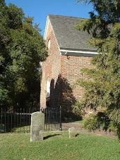
The third and present church is an exception to the general rule that
colonial churches be erected to set east and west, since it lies northeast to
southwest, with the chancel in the northeast end. The building is rectangular
measuring 60 feet long by 30 feet wide from the outside. The walls are made of
Flemish bond brick 21 inches thick. High up in the southern wall near the
eastern end is the date 1753 between the initials A.H. and E.H, traditionally
ascribed to the names of Anthony Holladay, church warden, and his wife Esther. This
commemorates their having given the parish a release deed for the church’s
site, long part of the Holladay’s Point plantation.
The time line for the present church began on 15 November 1751 when the
vestry first met to decide to build a new church, set an ad for a contractor to
build the new church in the Virginia Gazette on 24 April 1752, acceptance by
the vestry on 2 September 1755 and final completion 1 May 1756. The contractor,
Moses Allmand, was awarded ₤350 parceled out over the course of the construction
depending on progress made.
A vestry meeting of 1779 appointed a committee “to see if it would be any
advantage to build one or two small galleries in the Chuckatuck church, as the
church is much crowded and there is so large a congregation commonly attending
the church that there is not room in the pews for their reception.” The reason for the necessity to expand the
seating capacity owes itself to the beginnings of our Revolutionary War. The
Reverend John Agnew, a Tory loyalist, was the parish priest for both Chuckatuck
and Bennett’s Creek (Glebe) churches. During the spring of 1775, at a Sunday
morning service, the patriotic magistrate and vestryman, William Cowper, and
the Reverend Agnew got into an altercation at the Bennett’s Creek church. Cowper
threw out Reverend Agnew. With the support of the congregations of both
churches as documented in the Suffolk Parish Vestry book of 21 Oct 1778, the
Reverend Henry John Burgess became the new parish priest. Reverend Burgess was
apparently so popular a priest and patriot that the crowds were overflowing the
Chuckatuck church. However, the present balcony or gallery probably dates from
the 1870’s.
It appears that the Suffolk Parish
had a vestry for only two years after 1785, when the Church of England was
disestablished until 1826. The two churches of Glebe and Chuckatuck were left
to ruin. A new vestry, elected in 1826, returned the Chuckatuck Church to
serviceable condition. The church was in active use until 1856 and was again
restored following the Civil War. It was the custom after the Revolution to
name colonial churches after saints; hence, Chuckatuck church became St. John’s
in 1828. Vestry records indicate that the new name was not commonly used until
as late as 1845.
During the Civil War, on April 23,
1863 a small skirmish took place on the grounds of St. John’s. Federal
Lieutenant Roy had come along shore with an artillery battery at Ferry Point
and camped at St. John’s. Lt. Roy was creating havoc around the area and shot
two rounds of artillery into Chuckatuck with the idea of destroying it, until
Confederate Colonel J. J. Phillips, a native of Chuckatuck, routed the Federal
troops.
The current interior wainscoting
configuration and exterior stained glass windows date from a remodeling done in
1888. Since that time there have been additional modifications to the church’s
exterior. In approximately 1905, the southern entrance door on the right hand
side of the church was replaced with an arched window to match the other seven
windows making an even four on the north and south sides. A circular window was
bricked in above the western door and the two arched windows behind the altar
were bricked in and replaced with a new centerline window installed above and
behind the altar. The center aisle is paved with 18-inch square brown “red”
flagstone believed to have been delivered from England at the time of the
church’s construction.
Sometime in the early 1930’s David
C. Cotton, a former vestrymen, took it upon himself to stabilize the
foundations of the church, for it was feared the walls would come tumbling down.
He made excavations for five-foot lengths of concrete one at a time until the
job was completed reinforcing the old brick walls. The church today still
stands on those foundations.
Both Glebe and St. John’s have been
designated Virginia Historical Landmarks and have been placed on the Virginia
Landmarks Registry since 1972. These were the first two structures in the
Suffolk-Nansemond area to be so named. They were also nominated to be placed on
the National Register of Historic Places.